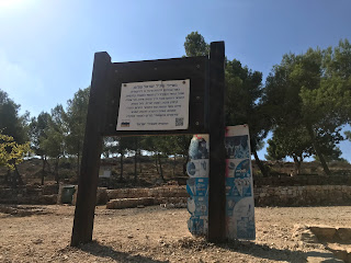
I entered Begin park (Ein Kobi is inside the park)
I went past an interesting memorial to Begin
and after about half an hour arrived back at Ein Kobi to rejoin the path
There was a nice walk downhill through the forest
Soon after, the track went under the railway line (the old Jerusalem line)
The walk followed the train track (and the green line) for quite a while - I had been here before on the Tel-Aviv to Jerusalem bike ride.
The trail went past a small spring (unfortunately with lots of graffiti)
and soon passed a large, well-developed spring (Ein Lavan) just inside Jerusalem
From here, there was a short hike up the hill and I found myself inside Jersualem. I was particularly surprised because I had been using my out-of-date map. It turned out well because my phone battery was dying and my charging cable didn't work so it was a good chance to pick up a new cable.
After a few minutes walking through the Kiryat HaYovel, the path headed down towards Ein Kerem
A view of the Ein Kerem campus of the Hadassah hospital in the distance
The beautiful town of Ein Kerem
The path went through the main street of Ein Kerem (and past lots of tourists), before heading down into a valley towards Sataf.
Unfortunately the path followed a sewerage line with some sort of outlets, so every 50 m or so there was the smell of sewerage. Not exactly the feeling of nature . . .
The path soon reached Sataf. There were an awful lot of stairs to climb to reach the site (where I have been many times before).
There were some good views on the climb up (better than the stairs)
At the Sataf junction, there were the explanation signs
and a good place for a coffee and pastry for some energy to keep going.
After leaving Sataf, there were some interesting cloud patterns
and I passed one of the Israel trail libraries
The path soon led to Kibbutz Tzuba, where I had been a few years ago at the motor control summer school
On the top of the hill were the ruins of the village of Suba
with some great views of the surrounding area
There was a big sign on the hill saying "agriculture will win". I'm not sure about that . . .
A memorial for one of the battles at Tzuba
I finished the day at Giv'at Ye'arim junction. Next to the junction was a half-completed hotel that was never opened, there are some good photos of it in this blog post


No comments:
Post a Comment